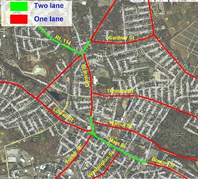
Here is an overlaid GoogleMaps image of greater Downtown Peabody, Ma.
I have draw BY MEMORY ** where the roads are one land (red) or two lanes (green) in each direction.
Someone pointed out on Old Fred's Blog that if Main Street were to be reduced from the current two lanes in each direction to one lane (approximately 800' long section), that this would NOT cause a bottleneck (as Gardner Park suggested) because it is already just one lane for the entire distance between Rt. 128 and Downtown Salem!
** If I have made an error... please let me know and I will try and correct it.
Peabody Fire Fighter James Rice Dies in House Fire. Fund for Rice family
and displaced residents established.
-
*Veteran Peabody fire fighter James Rice died tragically when he was
overcome by toxic fumes fighting a house fire on Hancock Street Friday. I
join my f...


